
Free Texas Water API Shows Well Depth, Water Tests and County Rules for Any Address
5 min read
- Type
- Press release
- Words
- 1,060
- Listed
- Nov 20 2026
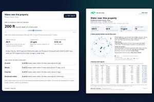
The "Water near this property" widget and the first page of its PDF report for a point near Weatherford, Parker County, Texas.
The live demo: type any Texas address and see the wells, the lab tests and the county rules for that point.
Page 1 of the PDF report: the nearest driller reports on a map and in a table, each linked to the state's record.
Page 2 of the report: lab tests of nearby wells against each limit, and the county's rules with their sources.
One call returns the answer as JSON: nearby wells, water quality counts and county rules.
TerraFunded's API, widget and three-page PDF report put what nearby wells say about water on any land listing with one line of HTML.
A family looking at one tract should not have to process a statewide file to learn how deep the neighbors had to drill.”
— Rodrigo Blanco, Founder and CEO of TerraFunded
DALLAS, TX, UNITED STATES, November 20, 2026 /EINPresswire.com/ -- TerraFunded today opened the TerraFunded Water API, a free service that answers one question for any point in Texas: what do the wells already drilled around here say about water?
Give it a latitude and a longitude and one call returns how deep nearby home wells are, where the water stood when they were finished, how the county changed over 20 years, how many tested wells nearby were above the drinking-water limits for arsenic, nitrate, fluoride and dissolved solids, and what the county requires for a well, a septic system and electricity.
Texas already publishes the raw records. Licensed drillers file a report with the state for every new well, and the Texas Water Development Board offers those reports as downloads and map services. What a buyer, a broker or a listing site still had to do was download and process a statewide file to learn about one property. The API does that work every night and returns the answer for the point.
There are three ways to use it.
The API: read-only JSON with an OpenAPI 3.1 description. Every figure comes with its number of wells, its distance and its years, and each driller report carries the state's report number and a link to the official record.
The widget: "Water near this property" goes on any parcel or listing page with one line of HTML and fits its own height.
The PDF report: three pages for any address, with a map and a table of the nearest well reports, the lab tests of nearby wells, the county rules with their sources, and how the analysis was made.
Anyone can try it with a Texas address at https://terrafunded.com/developers/demo. Near Weatherford, in Parker County, the answer on November 20 was 78 home wells within 2 miles, a typical depth of 200 feet with half of them between 163 and 260 feet, water standing at 85 feet, and new wells in the county 14% deeper than 20 years ago.
"The records are public, but a family looking at one tract should not have to process a statewide file to learn how deep the neighbors had to drill," said Rodrigo Blanco, Founder and CEO of TerraFunded. "We built this for our own buyers, and we are opening it to every land site, broker and developer in Texas."
The API is built on two open datasets TerraFunded publishes with a DOI under a CC BY 4.0 license: the Texas Well Atlas, from the state's driller reports with more than 290,000 home wells, reloaded every night, and the Texas Well Water Quality Atlas, from about 11,000 wells with lab tests since 1992 in the Texas Water Development Board's Groundwater Database and the Water Quality Portal of the USGS and the EPA. County rules cover all 254 counties, each with its official source and the date it was verified.
The service reports what was observed in wells that exist. It gives no probability for an undrilled tract and never says a place's water is good or bad; with fewer than 10 wells it returns only counts. The only way to know a well's water is to test it.
Keys are free on request at https://terrafunded.com/developers. The terms ask for a visible credit with a link. TerraFunded sells rural land in Texas; the API covers every point in the state, not only the company's tracts, and contains no listings.
Rodrigo Blanco is available for interviews and for collaborations with land sites, researchers, reporters and Texas water organizations: rodrigo@terrafunded.com.
About TerraFunded
TerraFunded is a Dallas-based company, founded in 2020 by Rodrigo Blanco and Luisa de Blanco, that sells rural Texas land directly to buyers. It publishes the Texas Well Atlas, the Texas Well Water Quality Atlas and a guide to rural land rules in all 254 Texas counties as free public tools. Learn more at https://terrafunded.com.
Rodrigo Blanco
TerraFunded
+1 216-630-4560
Legal Disclaimer:
EIN Presswire provides this news content "as is" without warranty of any kind. We do not accept any responsibility or liability for the accuracy, content, images, videos, licenses, completeness, legality, or reliability of the information contained in this article. If you have any complaints or copyright issues related to this article, kindly contact the author above.
